Phó Thủ tướng yêu cầu duy trì cấm đường, hạn chế người dân ra khỏi nhà
Phó Thủ tướng đánh giá bão số 3 là cơn bão rất mạnh, vì vậy các địa phương ven biển phải duy trì cấm đường, hạn chế tối đa người dân ra khỏi nhà đến sau 20h.
Phó Thủ tướng đánh giá bão số 3 là cơn bão rất mạnh, vì vậy các địa phương ven biển phải duy trì cấm đường, hạn chế tối đa người dân ra khỏi nhà đến sau 20h.
Chuyên gia khí tượng cho biết, 13h ngày 7/9, bão Yagi đi vào đất liền nước ta, đến 15h bão sẽ đi sâu vào các tỉnh phía Bắc gây mưa to, gió lớn.

Mưa to kèm gió mạnh do ảnh hưởng của hoàn lưu bão số 3 khiến hàng chục xe máy đi trên đường Hà Nội bị quật ngã.

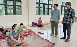
Quận Ba Đình, Hà Nội di dời người dân sống tại 5 chung cư, nhà tập thể cũ nguy hiểm cấp độ D tới nơi an toàn trước khi bão số 3 đổ bộ.

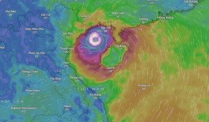
Lúc 10 giờ sáng nay, 7/9, bão số 3 đã vào vùng biển Quảng Ninh ghi nhận tại huyện Vân Đồn sức gió làm chìm thuyền của ngư dân ở bãi cát phía nam Cảng Cái Rồng.
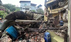
Phóng viên báo điện tử VTC News tại các điểm cầu Quảng Ninh, Hải Phòng, Nam Định, Thái Bình, Ninh Bình, Hà Nội cập nhật tình hình cơn bão số 3 đổ bộ vào đất liền.

Phó Thủ tướng yêu cầu cơ quan khí tượng cập nhật về đường đi, cường độ bão Yagi ít nhất từ 30 phút đến 1 tiếng 1 lần để người dân nắm bắt, có phương án phòng tránh.
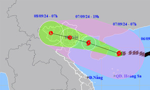
Dự kiến bão số 3 đi vào đất liền trong chiều nay gây gió mạnh cấp 10-12 ở Quảng Ninh, Thái Bình, Nam Định; Hà Nội mưa lớn, miền núi khả năng có lũ quét.
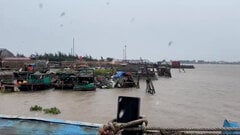
Bão số 3 ảnh hưởng tới vùng biển thuộc huyện Hải Hậu, Nam Định sáng nay, tàu thuyền đã vào nơi neo đậu an toàn, ngư dân ở lại trên thuyền để bảo vệ tài sản của mình.
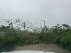
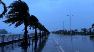
Sáng nay 7/9, siêu bão Yagi đã áp sát vào đất liền, tỉnh Quảng Ninh xuất hiện gió giật mạnh, mưa lớn, cây ngã đổ khắp nơi, cảnh báo thiên tai cấp độ 4.
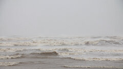
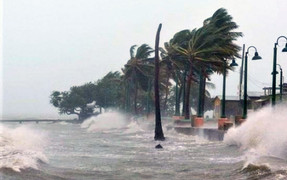
Bão số 3 giật cấp 17 đang di chuyển về phía đất liền các tỉnh miền Bắc gây mưa to trắng trời, gió giật kinh hoàng, sóng biển cao 2-3m ở Hải Phòng - Quảng Ninh.

Tại khu vực cảng cá Ninh Cơ (huyện Hải Hậu, Nam Định), hàng trăm ngư dân tìm cách bảo vệ tàu thuyền - tài sản lớn của họ - trước siêu bão Yagi sắp đổ bộ.

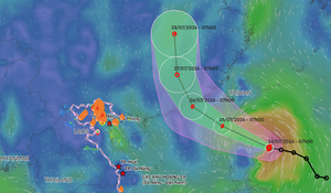
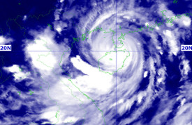
Sáng 7/9, bão số 3 (Yagi) cách Quảng Ninh - Thái Bình khoảng 150km, sức gió mạnh nhất gần tâm bão mạnh cấp 14, giật cấp 17.

Người dân Hà Nội tìm đủ cách gia cố trước giờ siêu bão Yagi đổ bộ, thậm chí mang xe container chặn trước cửa hàng.
5h ngày 7/9, bão số 3 (Yagi) giật cấp 17 chỉ còn cách bờ biển Quảng Ninh – Hải Phòng 160km, trên đất liền đã ghi nhận mưa lớn, gió giật mạnh.
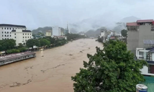
Bão số 3 đang tiến nhanh về đất liền nước ta gây mưa to kèm gió mạnh, theo chuyên gia, cao điểm mưa ở khu vực Bắc Bộ sẽ từ khoảng trưa đến đêm nay.
Thủ tướng Phạm Minh Chính ký Công điện số 88 yêu cầu các bộ ngành, địa phương tập trung ứng phó bão số 3 (bão Yagi) và mưa lũ sau bão.
Lúc 6h ngày 7/9, bão số 3 - cơn bão Yagi vẫn di chuyển hướng Tây Tây Bắc, sức gió mạnh nhất cấp 14 (150-166km/h), giật cấp 17, đất liền dự báo nhiều nơi mưa lớn.
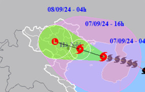
Bão số 3 (tên quốc tế Yagi) hiện vẫn rất mạnh, sức gió mạnh nhất vùng gần tâm bão lúc 4h cấp 14, giật cấp 17, cách Móng Cái (Quảng Ninh) khoảng 180km.

Ngay trong đêm 6/9, hàng trăm người dân tại khu tập thể A7 Tân Mai (quận Hoàng Mai, Hà Nội) vội vã di tản để đảm bảo an toàn trước khi bão Yagi đổ bộ.
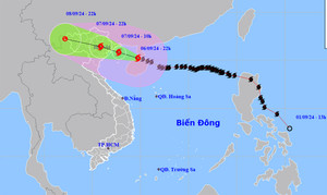
Trung tâm Dự báo khí tượng thuỷ văn quốc gia thông tin, trong 3 giờ qua, bão Yagi (bão số 3) tiếp tục giảm 2 cấp và đi vào vịnh Bắc Bộ.
Sức gió mạnh vùng gần tâm siêu bão Yagi hiện đang mạnh cấp 16, giật cấp trên cấp 17, bão sẽ đi vào đất liền Việt Nam gây mưa to, gió lớn, nguy cơ ngập lụt và sạt lở.

Đến gần 22h ngày 6/9, nhiều tuyến đường ở Hà Nội vẫn ùn tắc kéo dài sau cơn mưa lớn chiều cùng ngày.
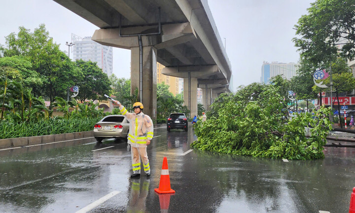
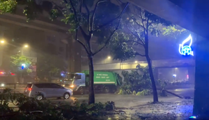
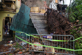
Trận mưa dông mạnh do ảnh hưởng của bão Yagi khiến cây cối đổ, gãy cành la liệt trên các phố ở Hà Nội, gây ra 11 vụ tai nạn.
Tối nay 6/9, bão Yagi giảm từ cấp 16 xuống cấp 15, sức gió mạnh nhất vùng gần tâm bão hiện giật cấp 17, cách Quảng Ninh khoảng 340km.
Yagi đang duy trì cấp siêu bão và tiến nhanh vào vịnh Bắc Bộ, dự báo sẽ đổ bộ đất liền các tỉnh Quảng Ninh-Thái Bình gây gió to, sóng biển mạnh và mưa lớn.
Để đảm bảo an toàn cho người dân trong phòng chống bão số 3, huyện Cô Tô (Quảng Ninh) ban hành Lệnh giới nghiêm từ 20h tối nay 6/9 cho đến khi bão tan.

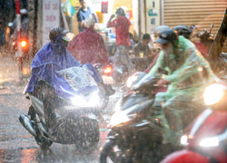
Công an Hà Nội phát đi khuyến cáo, do ảnh hưởng của bão Yagi, trong quá trình tham gia giao thông, người dân cần chú ý để đảm bảo an toàn.
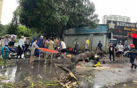
Trận mưa to kèm gió mạnh khiến một cây cổ thụ trên phố Hàng Cá bật gốc, đè trúng bức tường của ngôi nhà khiến 3 người bị thương.

Để ứng phó với siêu bão Yagi (bão số 3), nhiều tỉnh thành phía Bắc chủ động cho học sinh nghỉ học để phòng tránh.